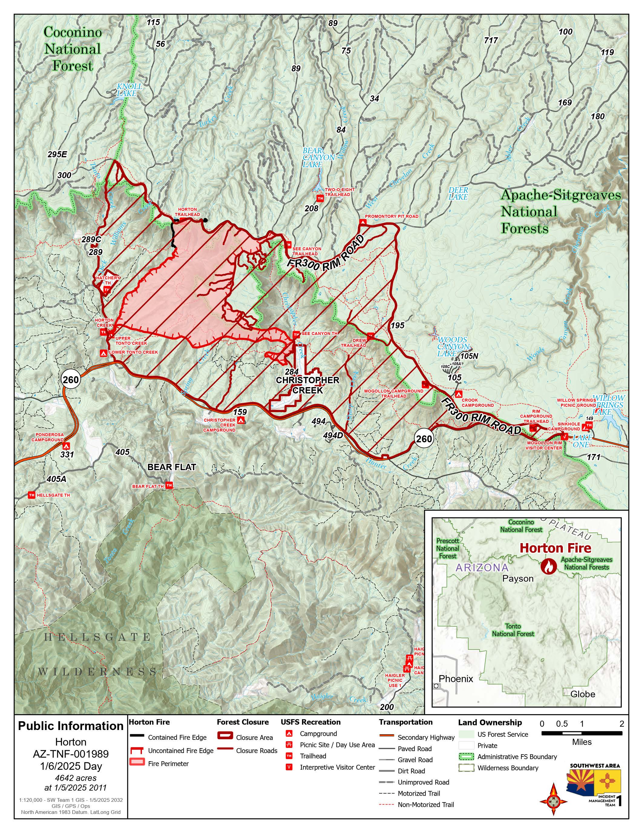
Acreage increases as Horton Fire grows towards handlines and control features; Public meeting tonight
Highlights: Firefighters were successful yesterday and last night in bringing the fire off the rim and closer to established control lines north of SR-260, east of Horton Creek, and west of Christopher Creek. With today’s predicted favorable weather conditions and as part of the full suppression tactics for the Horton Fire, crews plan
on continuing strategic burning operations to secure the fire perimeter near neighborhoods and along SR-260.
A public meeting is scheduled for 6 p.m. tonight, at The Church of Jesus Christ of Latter-Day Saints, located at 546 W Ashby Apple Dr., Payson, AZ 85541. Livestream available on the Tonto National Forest Facebook page.
Smoke: Smoke and flames continue to be visible in surrounding areas and from SR- 260. For more information on local smoke impacts, visit https://outlooks.wildlandfiresmoke.net/outlook/.
Operations: Crews will continue work around Promontory Point today and tonight. On the western side, crews continue strengthening the control line along the Horton Creek Trail and in the Tonto Creek Estates area. On the eastern side, crews are working in the Christopher Creek area, bringing fire along ridgelines for increased
protection of the Christopher Creek neighborhood. Aviation resources, both helicopters and drones, are working in between these two drainages to help remove ground fuels and move this fire as safely and securely as possible through the forested areas.
Weather: For the Horton Fire area, temperatures will rise a few degrees in the afternoon compared to Sunday. This warming will work to bring down humidity. Winds will be generally light, favoring terrain influences for its direction. Moisture will improve modestly overnight as the next weather system begins. A strong inversion will
set up tonight which in the presence of light winds and better humidity may create visibility impacts.
TFR: A Temporary Flight Restriction (TFR 5/0461) is in place for the Horton Fire through January 31. More information is available at https://tfr.faa.gov/save_pages/detail_5_0461.html.
Evacuations, Road Closures and Forest Orders: The communities of Christopher Creek, Hunter Creek, R-C Scout Camp, Tonto Creek Estates, Tonto Christian Camp, Tonto Fish Hatchery, Kohls Ranch, and Zane Grey Cabins are in SET evacuation status. Highway closures are not currently in effect due to the Horton Fire,
however reduced visibility due to smoke on SR-260 is possible. The health and safety of firefighters and the public are always the priority. Members of the public are asked to avoid the area. Travelers should monitor roadway status and conditions via AZ Department of Transportation at https://www.az511.com/.
A Forest closure order is in effect to protect public health and safety during the Horton Fire as well as protecting firefighting personnel engaging in wildland firefighting operations. More information can be found at https://www.fs.usda.gov/alerts/tonto/alerts-notices.
Fire details:
- Size: 3,598 acres
- Start date: December 14, 2024
- Cause: Under Investigation
- Location: Payson Ranger District, Arizona
- Containment: 17%
- Total personnel: 457
- Fuel: Timber, chaparral
- Resources: 8 crews, 32 engines, 3 helicopters, 1 bulldozer, 4 water tenders
Information Links and Contacts:
- Phone Number: (602) 551-7327 (8 a.m. - 8 p.m.)
- Email: [email protected]
- Inciweb: https://inciweb.wildfire.gov/incident-information/aztnf-horton-fire-2024
- Facebook: https://www.facebook.com/TontoNationalForest
