Prescribed fire planned October 8 through October 31 on the Chino Valley Ranger District
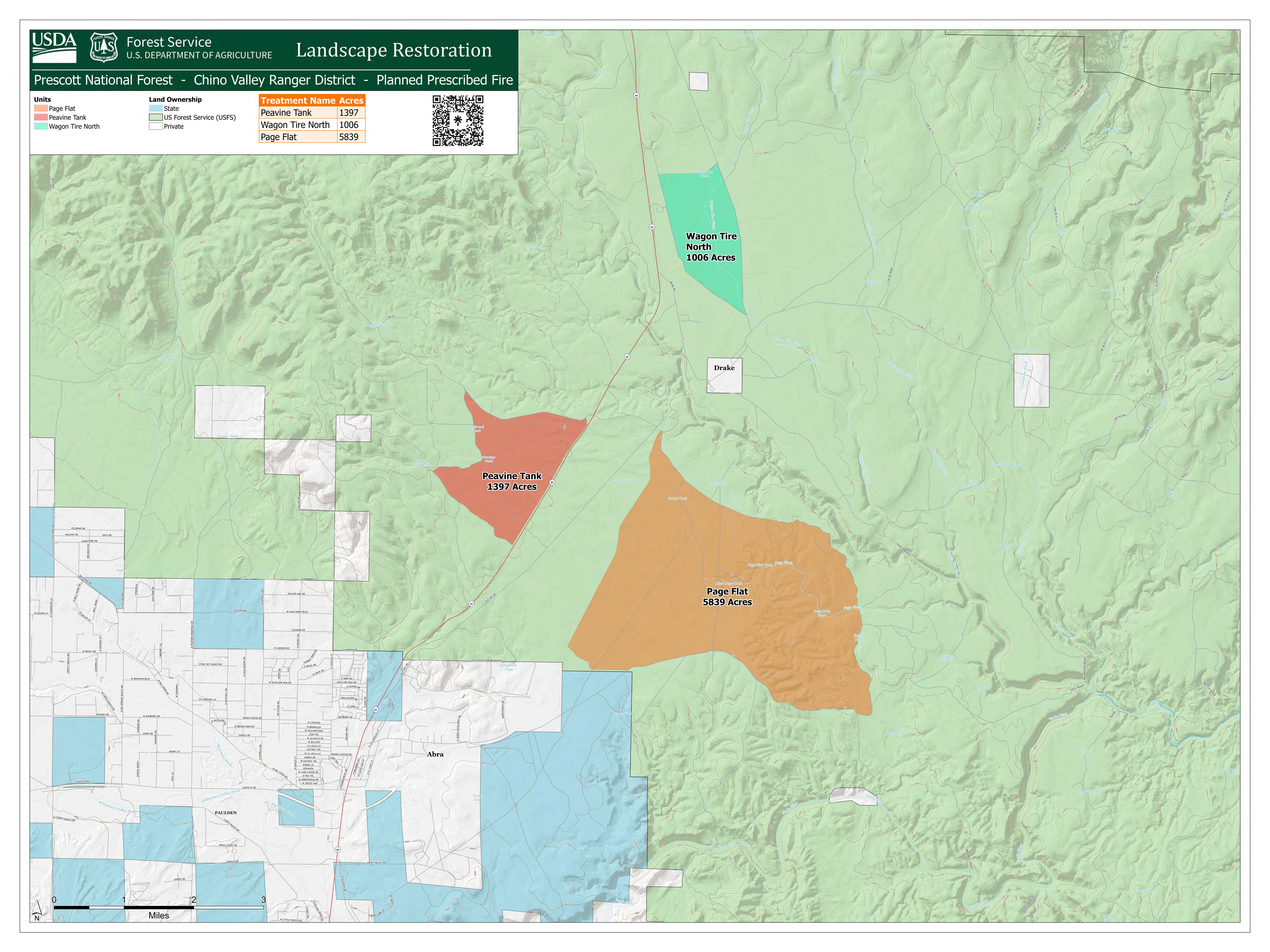
Fire managers on the Chino Valley Ranger District are looking for opportunities to treat fuels across the district at several locations in the Chino Landscape Project Area (see the map below). Prescribed fire operations are planned to start as early as Tuesday, October 8th, 2024, and continue through Friday, October 31st, 2024. Fire managers plan to use a variety of ground and aerial resources to meet the project objectives. Expect smoke impacts to be light to moderate and visible from multiple locations including Chino Valley, Paulden, Prescott and surrounding area communities.
Fire managers understand that to continue to improve landscape resiliency prescribed fires must be planned in advance and implemented during the appropriate conditions to obtain the most positive outcomes. The nature of the restoration and hazardous fuels reduction objectives required for these prescribed burns include drier conditions, prescribed burns below will not be implemented concurrently or in order listed.
Peavine Tank RX (T18N, R1W, Sec 1,2,11,12,13,14) – is a 1,396-acre burn north of Chino Valley and west of Highway 89. Vegetation is primarily grass with small areas of brush and juniper encroachment.
Page Flat RX (T18N, R1W, Sec 22,23,26,27) is a 5,839-acre burn north of Chino Valley and east of Highway 89. Vegetation is comprised of primarily grass juniper and residual slash from previous grassland restoration projects.
Wagon Tire (North) RX (T19N, 1W, Sec 16,17,21,22. T18N, R1W, Sec 32,33) is a 1005-acre broadcast burn located east of Highway 89, north of Chino Valley near Drake. Vegetation is scattered juniper and grass. Smoke will be visible in the immediate areas of the burn activity including Highway 89. It is possible that there could be minor delays on Highway 89.
The objective of these prescribed burns is to improve native vegetation conditions by reducing shrub and juniper fuel loading while also enhancing grasslands restoration. The prescribed burn plan criteria for this project includes hot, dry conditions that are necessary to stimulate grass growth and reduce encroaching juniper trees. Fire managers are closely monitoring weather and fuels conditions with equal attention to the wildfire activity and firefighting resources on the Prescott National Forest as well the resource availability of nearby wildland fire partner agencies.
Prescribed fires on National Forest System land may only be implemented when the conditions at the project site meet the objectives and criteria outlined in the prescribed burn plan. These criteria include acceptable ranges for wind, humidity, fuel moisture and temperature to name a few. If any of the conditions are outside the prescription, the prescribed fire will not be implemented. The Forest Service is fully committed to using this critical tool safely and effectively in collaboration with the tribes, partners, and the community.
In the interest of safety, forest visitors are reminded to obey all traffic signs and use caution when traveling in the vicinity of prescribed burns as firefighters and fire-related traffic will be in the area.
Prescott National Forest’s land management strategy is centered on long-term forest health and the strategy includes reducing forest fuels and using prescribed fire on the landscape. Using low to moderate fire behavior, we can better protect communities, while improving watersheds, wildlife habitat, and forest health.
All prescribed fire activity is dependent on the availability of personnel and equipment, weather, fuels and conditions that minimize smoke impacts as much as possible, and approval from the Arizona Department of Environmental Quality (www.azdeq.gov).
Messages will be posted on social media when prescribed fires are ignited on the Prescott National Forest:
Facebook https://www.facebook.com/PrescottNF/
Twitter https://twitter.com/PrescottNF
For fire information please call (928) 777-2200; or stay up to date on Prescott National Forest news by checking the Prescott NF website and following us on Facebook and Twitter.


