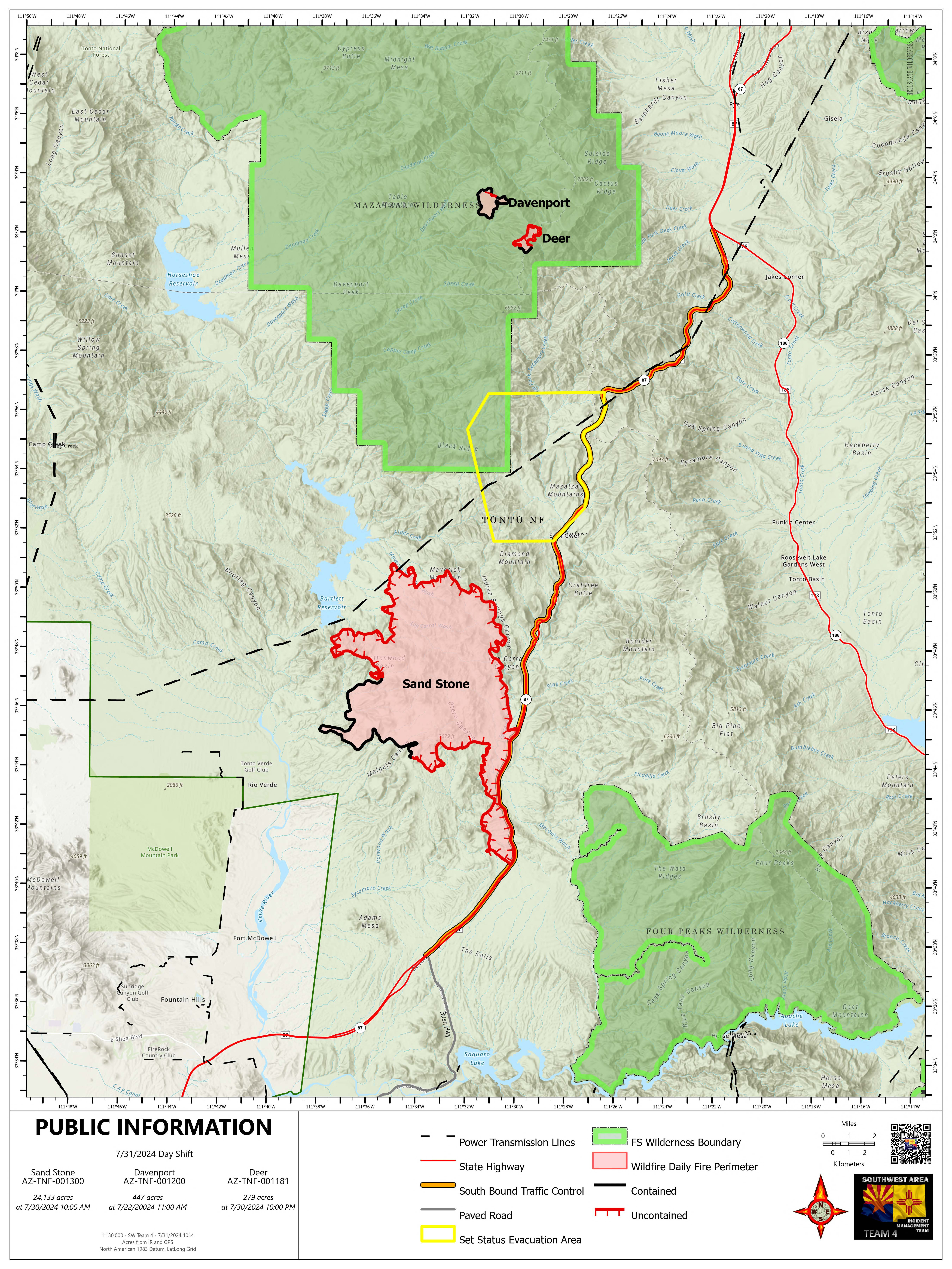
Containment Efforts Advance on Sand Stone, Deer, and Davenport Fires with New Aerial Support
The Maricopa County Sheriff’s Office has moved the community of Sunflower to “set” status. “Set” status means residents should identify the closest shelter or safe space, prepare an emergency kit, listen to public health officials and be ready to leave the area. The Ready, Set, Go! program is a nationwide program to educate residents about steps to take during an emergency. Sign up for emergency alerts at ready.maricopa.gov.
Weather: On the Sand Stone Fire, weather is predicted to be in the upper 90s. Temperatures over the Deer and Davenport Fires will be about 15 degrees lower. There is a 30-35% chance of lightning and thunderstorms today.
Safety: The health and safety of firefighters and the public are always the first priority. A temporary flight restriction (TFR) is in place over the area, which includes uncrewed aircraft or drones. Flying drones near wildfires is dangerous for pilots and firefighters and can bring wildfire suppression efforts to a halt. Know before you fly. If you fly, we can’t. More information can be found at: https://uas.nifc.gov/.
Smoke: Smoke may be visible from Fountain Hills, Sunflower, Rio Verde, Goldfield, and unincorporated communities in the Rio Verde Foothills. An interactive smoke map is available at https://fire.airnow.gov/. A daily smoke forecast for the Sand Stone Fire is available at www.azdeq.gov/wildfire/forecast/sandstonefire.
Closures: Southbound State Route 87 is closed between State Route 188 to Bush Highway. The Incident Management Team is working closely with the Arizona Department of Transportation and Department of Public Safety to determine when the highway can be safely reopened. See https://az511.gov/ for a map of the closure.
The Tonto National Forest has issued a closure order for the Sand Stone Fire. More information can be found on the Tonto National Forest website: https://www.fs.usda.gov/alerts/tonto/alerts-notices/. Trail users should avoid using the Arizona National Scenic Trail near the fire area.
Total personnel on all incidents: 470
Sand Stone Fire
Start Date: 7/25/2024
Acres: 24,133
Containment: 20%
Fuels: Grass, brush
Operations: The Sand Stone Fire provides an ideal opportunity to utilize scooper planes, a specific type of aircraft that can “scoop” up to 1350 gallons of water by skimming the surface of lakes and then dropping water onto the fire. This approach is particularly effective for the Sand Stone Fire because it is situated close to Bartlett Lake and burning through grasses and brush. The two scoopers are targeting their efforts on the west side of the fire to moderate activity near the powerlines. Ground crews will continue to secure the movement of the fire on the east side as it backs down into Indian Springs Canyon. The fire continues to progress to the north, producing a visible smoke column as temperatures increase fire activity in the afternoons. Three Type 1 helicopters are also supporting ground crews by dropping water on the northwestern perimeter to cool the fire’s edge.
Deer Fire
Start Date: 7/17/2024
Acres: 279
Containment: 18%
Fuels: Grass, brush, timber
Operations: The Deer Fire, burning within the Mazatzal Wilderness, remains at low intensity as it moves through stands of pine trees, cleaning up fuels along the forest floor. Containment has increased to 18%.
Davenport Fire
Start Date: 7/19/2024
Acres: 447
Containment: 93%
Fuels: Grass, brush
Operations: No activity has been observed on the Davenport Fire within the Mazatzal Wilderness for over two weeks. Containment for the Davenport Fire is now being reported at 93%
Important fire information:
InciWeb: Sand Stone
Fire Fire email: [email protected]
Information Phone: (480) 409-9683
Social Media: X @TontoForest and Facebook @TontoNationalForest


