Blue Stem Prescribed Fire Complete, Rx Burns Continuing on Williams Ranger District This Week
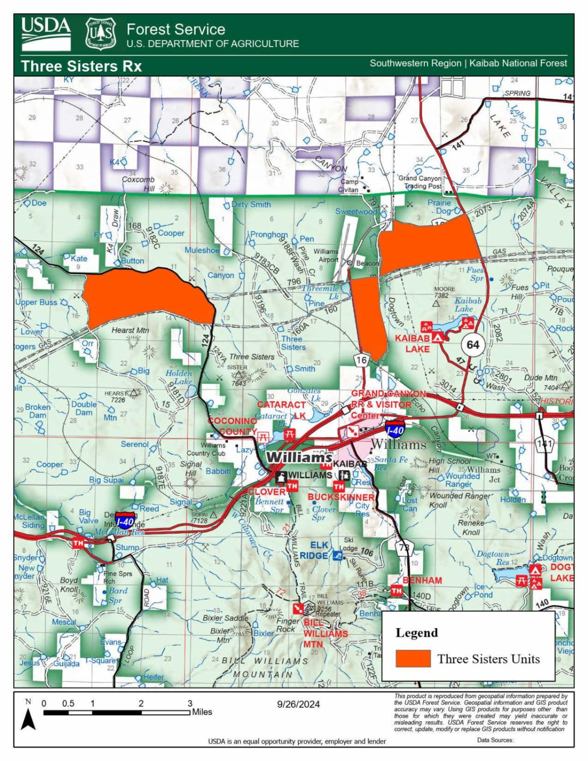
Fire managers have successfully treated 6904 acres on Tusayan Ranger District last week completing the Blue Stem Rx Fire Project and are moving back to the Three Sisters Prescribed Fire Project located just north of the City of Williams and Interstate 40, south of forest road 124, between Airport Road and the west side of Highway 64.
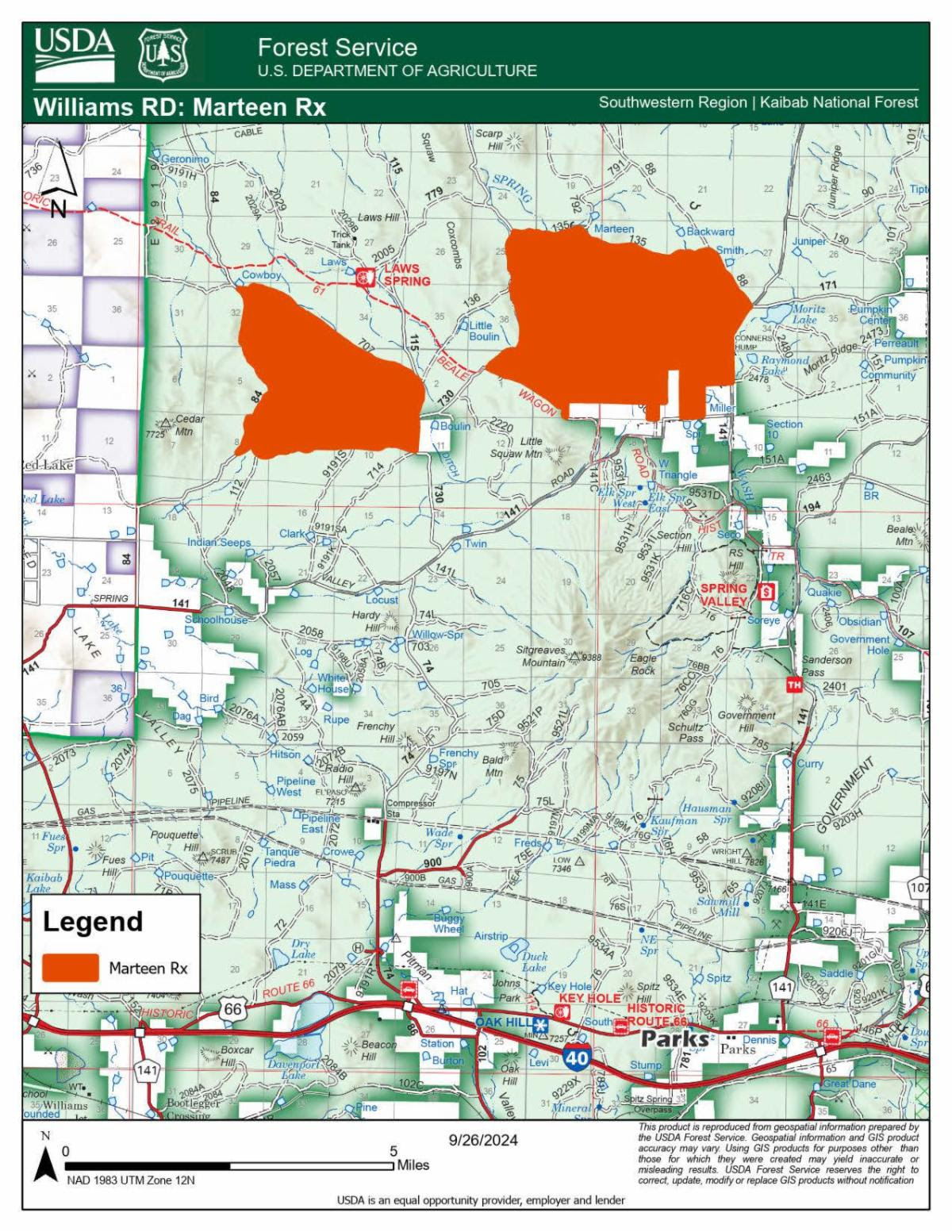
Improving weather conditions have re-opened the opportunity for crews to return working in the local areas near Williams and Spring Valley. Plans are in place to begin ignitions on approximately 1500 acres of the Pronghorn and Cataract units of Three Sisters project on Tuesday October 8, and then move to the 4200 acre Marteen East Rx Fire Project later this same week. This project is located north of Spring Valley, west of forest road 144, and east of Laws Spring.
Area residents and visitors can expect to see and hear a helicopter in these area, as aerial ignitions will occur on portions of the burn. Aerial-drone systems should not be used near the active project area, as they could interfere with aircraft operations.
Smoke will be highly noticeable from the Williams area, particularly the Country Club / Elephant Rocks Golf Course, H.A. Clark Memorial Field Airport, Cataract Lake Park, Kaibab Lake, Ash Fork, Valle, Parks, Spring Valley, portions of State Route 64 and I-40. Smoke is expected to lift during the day and travel northeast away from developed areas adjacent to these burns, however cooler overnight temperatures may cause smoke to settle into low-lying areas surrounding the burn location.
No road or trail closures are planned as part of these prescribed fire operations however, fire personnel and vehicles will be visible to the public at these locations. Motorists are reminded to use caution and drive with heightened awareness when passing through active project areas.
The Pine Flat Rx Fire Project is also scheduled to receive treatments this fall and could potentially see activity as early as the weekend ahead. This project is located on the south end of the Williams Ranger District, east of forest road 354, and west of Round Mountain.
Fire managers recognize that community members may be sensitive to smoke, and use strategies to limit the amount and duration. This includes dividing large projects into smaller units so that crews can focus efforts where and when conditions will help smoke disperse away from developed areas and ventilate quicker, reducing the impacts to local residents and businesses. Prescribed fires with shorter-term impacts to air quality help significantly reduce the risks to public health and safety.
Goals of prescribed fire treatments include decreasing the threat of unnatural severe wildfire and potential negative consequences to the community, improving forest health, and reintroducing fire to an ecosystem that relies on frequent fire to maintain resilience. Prescribed fires help reduce hazardous fuels that have accumulated due to drought, climate change, insects and disease, and decades of fire suppression. Fire also recycles nutrients back to the soil, promotes the growth of trees, wildflowers, and other plants, and improves habitat for threatened and endangered species. Our land management strategy is centered on long-term forest health, including reducing forest fuels and using prescribed fire on the landscape. These efforts align with the Forest Service’s 10-year Wildfire Crisis Strategy which aims to increase prescribed fire and other treatments to improve forest resiliency for generations to come.
All prescribed fires are subject to approval by an agency administrator and by the Arizona Department of Environmental Quality. The department’s Air Quality Division: Smoke Management webpage provides details about its air quality program.
To learn more about smoke and public health, visit bit.ly/SmokeHealthAwareness.
The Kaibab National Forest remains committed to providing the public with ongoing updates with as much advance notice as possible. Sign up to receive Kaibab NF news releases in your email.
Additional information can be found on the Kaibab NF website, X, Facebook, Flickr, or by calling or local ranger stations.


