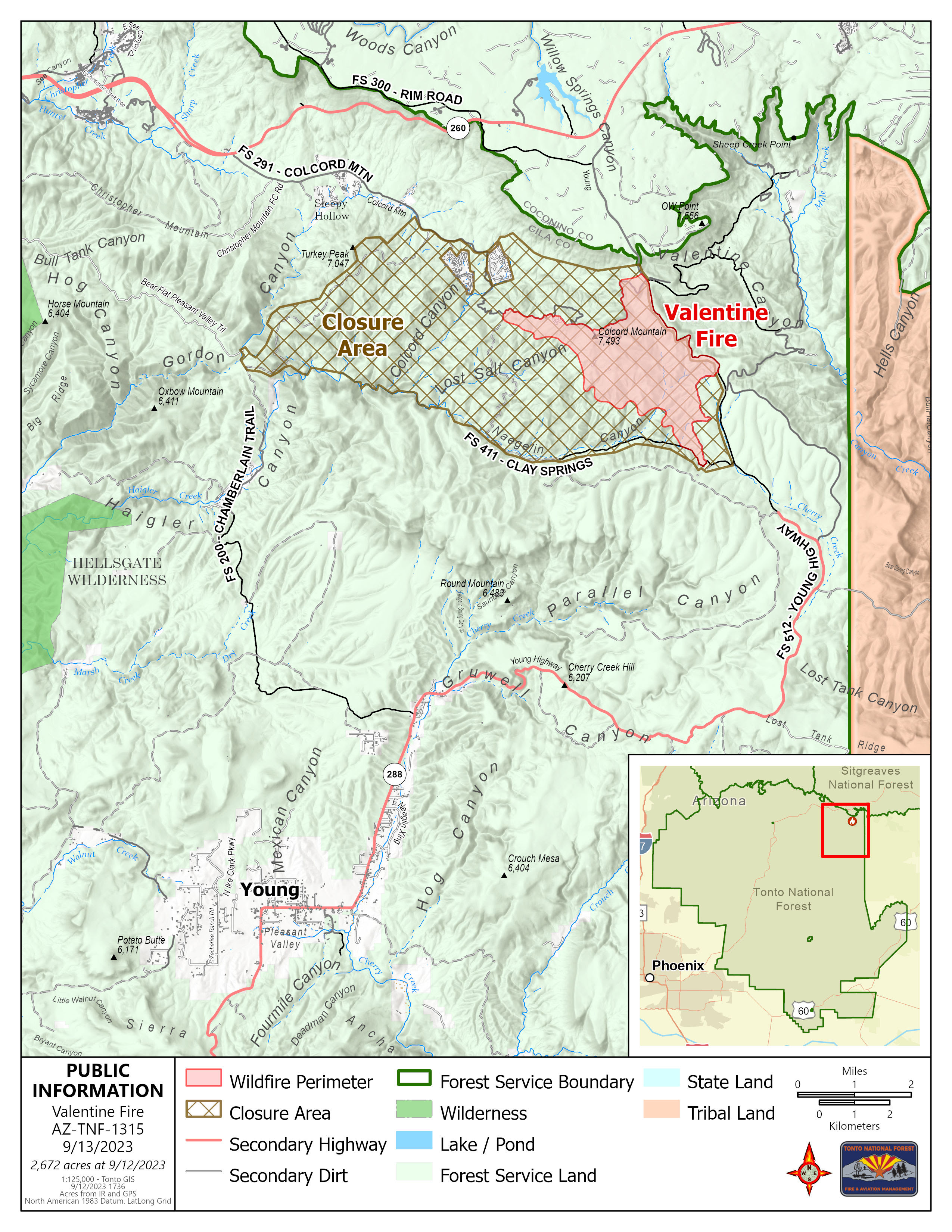
Crews Continue to Make Progress on Valentine Fire, Now 48% Contained
Crews were able to make good progress as moisture and precipitation remained mostly north of the fire area.
Operations: Yesterday, crews on the northwestern portion of the fire area cleaned up containment lines and looked for alternative containment options to avoid sparse fuel areas. On the eastern portion of the fire area, crews scouted some areas near the 411 road and 512 road intersection, held current lines, and worked on backing fire down some of the ridges. Today, crews will continue with prep work to the northwest, while crews to the east look to bring fire up from the 411 road to meet the backing fire moving south down some of the ridges. Some resources may be rotating out and new resources rotating in over the coming days.
Fire Ecology: When fire heats up leaves or needles on trees, the water in them expands, bursting the cell walls so they can no longer function. This exposes the leaf material to more oxygen causing the leaf material to begin to oxidize, and also allows the water that was in the cells to evaporate. Scorch is sometimes used as a measure for fire severity.
Weather: Yesterday, moisture formed but stayed mostly north of the fire area with a few scattered storms. Today, conditions will be similar as temperatures remain cool and possible scattered storms over the fire area. Moisture is expected to move out Wednesday night as a drying trend begins Thursday with only a slight chance of isolated showers through the weekend.
Closures: An emergency closure order for the Valentine Fire went into effect 6 a.m. Sept. 5, 2023. The public is asked to avoid the fire area. The purpose of the closure order is to protect public health and safety during the Valentine Fire, and to protect assigned firefighting personnel engaging in wildland firefighting operations. Signs and gates will be in place to remind the public not to enter the fire area. Please visit the Alerts and Notices page for more information: https://www.fs.usda.gov/alerts/tonto/alerts-notices.
Safety: The health and safety of firefighters, and the public are always the highest priority. Members of the public are asked to avoid the fire area.
Smoke: Smoke from the Valentine Fire may be visible in the surrounding areas for many days. Smoke will be heavier in the mornings as it settles into the lower elevations and will lift as temperatures increase. Smoke-sensitive individuals and people with respiratory problems or heart disease are encouraged to take precautionary measures An interactive smoke map at https://fire.airnow.gov/ allows you to zoom into your area to see the latest smoke conditions.
Fire details:
- Size: 2,672 acres
- Start Date: August 16, 2023
- Cause: Lightning
- Containment: 48%
- Total personnel: 180
- Location: 11 miles northeast of Young, Arizona and 27 miles east of Payson, Arizona
- Fuels: Ponderosa Pine, Hardwood litter and timber
Official fire information:
Tonto National Forest: https://www.fs.usda.gov/main/tonto/fire
InciWeb: https://inciweb.nwcg.gov/incident-information/aztnf-valentine-fire
Fire Email: [email protected]


