Arizona Emergency information Network Logo
Arizona Emergency information Network
  • Home
  • Emergency Bulletins
  • Hazards
    • Active Shooter
    • Bioterrorism
    • Chemical Emergencies
    • Cybersecurity
    • Drought
    • Dust Storms
    • Earthquakes
    • Extreme Heat
    • Flooding
    • Influenza
    • Landslides & Debris Flow
    • Nuclear Explosion
    • Palo Verde Generating Station
    • Power Outage
    • Space Weather
    • Radiological Dispersion Device
    • Thunderstorms
    • Tornadoes
    • Wildfire
    • Winter Weather
  • Get Prepared
    • Plan
    • Prepare
    • Inquire
    • Inspire
  • Resources
    • About AzEIN
    • Publications
    • ASL Glossary
  • Emergency Kit Cookoff
    • Recipes
    • Submit a Recipe

Main menu

  • Home
  • Emergency Bulletins
  • Hazards
    • Active Shooter
    • Bioterrorism
    • Chemical Emergencies
    • Cybersecurity
    • Drought
    • Dust Storms
    • Earthquakes
    • Extreme Heat
    • Flooding
    • Influenza
    • Landslides & Debris Flow
    • Nuclear Explosion
    • Palo Verde Generating Station
    • Power Outage
    • Space Weather
    • Radiological Dispersion Device
    • Thunderstorms
    • Tornadoes
    • Wildfire
    • Winter Weather
  • Get Prepared
    • Plan
    • Prepare
    • Inquire
    • Inspire
  • Resources
    • About AzEIN
    • Publications
    • ASL Glossary
  • Emergency Kit Cookoff

Fire area closure order anticipated for Wilbur Fire

6/07/2023 - 10:43 am

Fire area closure order anticipated for Wilbur Fire

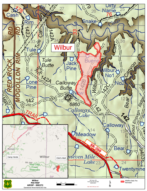
Crews continue to manage the Wilbur Fire, a lightning-caused wildfire located 8.5 miles west of Clints Well, Ariz., that is currently at 472 acres.

Highlights: Minimal growth occurred over the Wilbur Fire allowing crews to begin hazard tree felling operations along State Route (SR) 260 as a coordinated effort with the Arizona Department of Transportation. As crews work to complete prep along the highway, traffic delays can be expected through Thursday. In addition to the traffic delays, a forest closure order is anticipated to go in effect on Thursday June 8, 2023.

Operations: Yesterday (Tuesday, June 6, 2023) firefighters patrolled, monitored and secured established holding features from previous days ignitions. Today resources will continue with line prep and hazard tree felling operations on SR 260. Once firefighters have completed prep work, additional tactical firing operations are planned for construction along the fire perimeter when conditions are favorable to minimize smoke impacts.

Weather: Temperatures are forecasted to be 72 degrees. Winds are expected to be from the southwest at 5-15 miles per hour with gust up to 25. Excellent ventilation is forecasted where smoke can disperse out of the surrounding area throughout the day.

Safety: The Wilbur Fire is burning in an area with an extensive road system that firefighters are using both for travel and as control features -- including Hwy 260. In the interest of public and firefighter safety forest visitors are asked to travel with caution as fire crews will be on roadways during operations.

Smoke: Impacts from smoke can be expected to be light throughout the week and visible from multiple locations including the Verde Valley and along Lake Mary Road (Forest Highway 3), SR 260, and SR 87. As temperatures cool overnight smoke may linger in drainages and valleys until daytime winds surface.

Map of the Wilbur Fire closures beginning June 8, 2023

Map of the Wilbur Fire closures beginning June 8 2023.png

Map of the Wilbur Fire closures beginning June 8 2023
Keywords: 
Fire area closure order, Wilbur Fire, west of Clints Well, traffic delays expected, light smoke impact, light smoke, smoke
Source: 
Coconino National Forest
Apache-Sitgreaves National Forests  Arizona Department of Environmental Quality  Coconino County  Coconino National Forest  Kaibab National Forest  Maricopa County  Mingus Mountain  Navajo County  ozone high pollution advisory  Payson  Prescott National Forest  prescribed burn  Show Low  smoke  Stage 1 fire restrictions  Tonto National Forest  Valentine Fire  wildfire  Yavapai County  Young 

Tweets by AzEIN

Arizona State Seal
  • Contact Us
  • Statewide Web Policies

© 2019 Copyright AZEIN All Rights Reserved

  • Facebook
  • Twitter
  • Youtube
  • RSS