Arizona Emergency information Network Logo
Arizona Emergency information Network
  • Home
  • Emergency Bulletins
  • Hazards
    • Active Shooter
    • Bioterrorism
    • Chemical Emergencies
    • Cybersecurity
    • Drought
    • Dust Storms
    • Earthquakes
    • Extreme Heat
    • Flooding
    • Influenza
    • Landslides & Debris Flow
    • Nuclear Explosion
    • Palo Verde Generating Station
    • Power Outage
    • Space Weather
    • Radiological Dispersion Device
    • Thunderstorms
    • Tornadoes
    • Wildfire
    • Winter Weather
  • Get Prepared
    • Plan
    • Prepare
    • Inquire
    • Inspire
  • Resources
    • About AzEIN
    • Publications
    • ASL Glossary
  • Emergency Kit Cookoff
    • Recipes
    • Submit a Recipe

Main menu

  • Home
  • Emergency Bulletins
  • Hazards
    • Active Shooter
    • Bioterrorism
    • Chemical Emergencies
    • Cybersecurity
    • Drought
    • Dust Storms
    • Earthquakes
    • Extreme Heat
    • Flooding
    • Influenza
    • Landslides & Debris Flow
    • Nuclear Explosion
    • Palo Verde Generating Station
    • Power Outage
    • Space Weather
    • Radiological Dispersion Device
    • Thunderstorms
    • Tornadoes
    • Wildfire
    • Winter Weather
  • Get Prepared
    • Plan
    • Prepare
    • Inquire
    • Inspire
  • Resources
    • About AzEIN
    • Publications
    • ASL Glossary
  • Emergency Kit Cookoff

Lakeside Ranger District completes prescribed fire operations on Mud Springs

11/09/2023 - 1:44 pm

UPDATE

Fire crews completed ignitions on the Mud Springs prescribed fire on Nov. 8, 2023. Residual smoke is expected to diminish over the next few days and air quality impacts to Vernon and adjacent communities should continue to improve. More information on air quality is available at https://www.airnow.gov/.

The 1,829-acre prescribed fire is 3 miles south of Vernon and within Forest Road 224/Apache County Road 3140, Forest Road 5B, Forest Road 5, Forest Road 3D, Forest Road 44, and Forest Road 3.

Prescribed fires are an effective tool for restoring fire-dependent ecosystems and reducing the risk of high-severity wildfires. Fire managers use prescribed fire to improve forest health, remove hazardous fuels, increase firefighter safety, enhance wildlife habitat, and protect communities and watersheds.

Landscape treatments such as these planned on the Apache-Sitgreaves National Forests align with the Forest Service's 10-year Wildfire Crisis Strategy, which aims to increase the use of fire on the landscape and other treatments to improve forest health.

Visit the A-S National Forests website at https://www.fs.usda.gov/asnf and follow us on Facebook https://www.facebook.com/apachesitgreavesnfs.

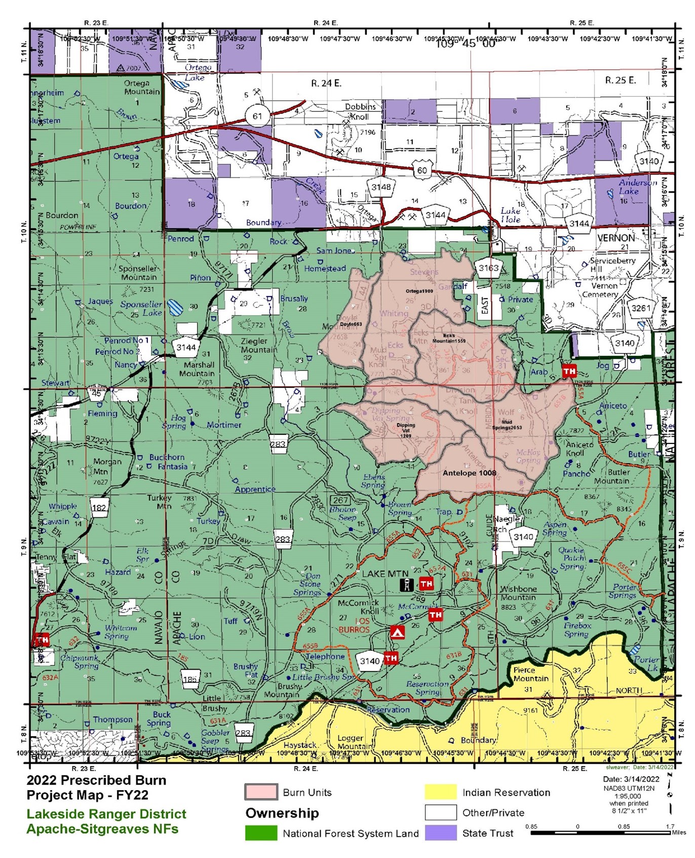
A map of the Lakeside East prescribed burn November 9 2023.jpg

A map of the Lakeside East prescribed burn November 9 2023
Keywords: 
Prescribed Fire, smoke, Mud Springs, Apache-Sitgreaves National Forests, Forest Service's 10-year Wildfire Crisis Strategy, Vernon, Lakeside Ranger District
Source: 
Apache-Sitgreaves National Forests
Apache-Sitgreaves National Forests  Arizona Department of Environmental Quality  Coconino County  Coconino National Forest  Flagstaff  Kaibab National Forest  Maricopa County  ozone high pollution advisory  Payson  Prescott National Forest  prescribed burn  Prescribed Fire  smoke  Stage 1 fire restrictions  Tonto National Forest  Valentine Fire  Verde Ranger District  wildfire  Yavapai County  Young 

Tweets by AzEIN

Arizona State Seal
  • Contact Us
  • Statewide Web Policies

© 2019 Copyright AZEIN All Rights Reserved

  • Facebook
  • Twitter
  • Youtube
  • RSS