Operations to begin on the Kendrick Prescribed Fire Project June 1 on Williams Ranger District
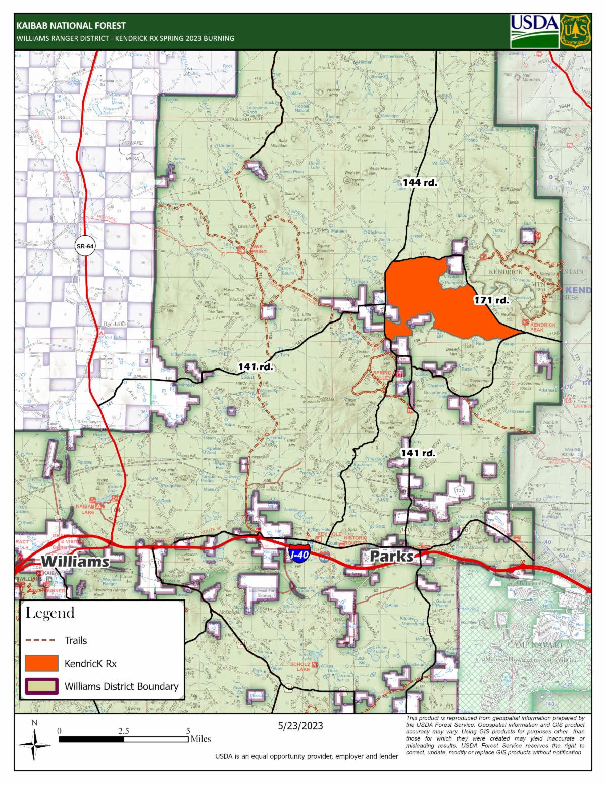
Prescribed fire operations are continuing at various locations across the south zone of the Kaibab National forest this spring with the next project to be treated near Kendrick Mountain. The 4052 acre Kendrick Rx project will begin on Thursday this week. The planned treatments will begin just northwest of Spring Valley, east of FR144 and south of FR171.
Area residents and visitors may see and hear a helicopter in the area, as aerial ignitions will occur on portions of this burn. Citizens are strongly urged to refrain from using any type of aerial-drone systems near the active project area that could potentially interfere with aircraft operations.
Daytime winds are forecasted to carry smoke northeast, however some smoke is expected to impact Pumpkin Center on the west side of Kendrick Mountain. Smoke will likely be visible from Spring Valley, Parks, Williams, and from Highway 180, state route 64, and Interstate-40. Residual smoke may settle into drainages and low-lying areas overnight but will lift and ventilate shortly after sunrise. Fire managers will continue to coordinate closely with partners and communities within and adjacent to the Kaibab National Forest to minimize impacts as much as possible.
There are no trail or area closures in the vicinity of this project.
The spring of 2023 has presented a unique opportunity for proactive prescribed burning to continue due to the preceding winter that resulted in higher than normal moisture levels enduring in the forest. Exact ignition dates are dependent upon current environmental conditions at each specific location that align with the parameters outlined in the project burn plan.
All prescribed fires are subject to approval by an agency administrator, and by the Arizona Department of Environmental Quality. The department’s Air Quality Division: Smoke Management webpage provides details about its air quality program. To learn more about smoke and public health, visit bit.ly/SmokeHealthAwareness.
The Kaibab National Forest remains committed to providing the public with ongoing updates with as much advance notice as possible. Sign up to receive Kaibab NF news releases in your email.
Our land management strategy is centered on long-term forest health, including reducing forest fuels and using prescribed fire on the landscape. Prescribed fires help reduce hazardous fuels that have accumulated due to drought, climate change, insects and disease, and decades of fire suppression. Fire also recycles nutrients back to the soil, promotes the growth of trees, wildflowers, and other plants, and improves habitat for threatened and endangered species. These efforts align with the Forest Service’s 10-year Wildfire Crisis Strategy which aims to increase prescribed fire and other treatments to improve forest resiliency for generations to come.
Additional information can be found on the Kaibab NF website, Twitter, Facebook, Flickr, or by calling the local ranger stations.


