Arizona Emergency information Network Logo
Arizona Emergency information Network
  • Home
  • Emergency Bulletins
  • Hazards
    • Active Shooter
    • Bioterrorism
    • Chemical Emergencies
    • Cybersecurity
    • Drought
    • Dust Storms
    • Earthquakes
    • Extreme Heat
    • Flooding
    • Influenza
    • Landslides & Debris Flow
    • Nuclear Explosion
    • Palo Verde Generating Station
    • Power Outage
    • Space Weather
    • Radiological Dispersion Device
    • Thunderstorms
    • Tornadoes
    • Wildfire
    • Winter Weather
  • Get Prepared
    • Plan
    • Prepare
    • Inquire
    • Inspire
  • Resources
    • About AzEIN
    • Publications
    • ASL Glossary
  • Emergency Kit Cookoff
    • Recipes
    • Submit a Recipe

Main menu

  • Home
  • Emergency Bulletins
  • Hazards
    • Active Shooter
    • Bioterrorism
    • Chemical Emergencies
    • Cybersecurity
    • Drought
    • Dust Storms
    • Earthquakes
    • Extreme Heat
    • Flooding
    • Influenza
    • Landslides & Debris Flow
    • Nuclear Explosion
    • Palo Verde Generating Station
    • Power Outage
    • Space Weather
    • Radiological Dispersion Device
    • Thunderstorms
    • Tornadoes
    • Wildfire
    • Winter Weather
  • Get Prepared
    • Plan
    • Prepare
    • Inquire
    • Inspire
  • Resources
    • About AzEIN
    • Publications
    • ASL Glossary
  • Emergency Kit Cookoff

Prescribed fire planned for Pleasant Valley Ranger District

4/21/2023 - 2:57 pm

Fire officials are planning a prescribed fire operation on the Pleasant Valley Ranger District, April 26-28, 2023.

Fire specialists will be burning a prescribed fire unit north of Nail Ranch along Forest Road 512, a total of 938 acres of broadcast burning of pine needles and brush.

Experienced fire and fuels specialists on the Tonto National Forest build prescribed fire plans using the most up-to-date science and modeling along with their combined on the ground fire and fuels experience.

The Forest Service will post signs on Forest Road 512. Officials urge motorists to use extreme caution while driving through the area and to slow down for the safety of firefighters and the public.

Expect smoke to impact the town of Young, Nail Ranch, Frog Pond and other private inholdings in the area along with Forest Roads 512, 100, and 101. Learn more about smoke impacts on the Arizona Department of Environmental Quality website.

For the latest news and information about the Tonto National Forest, follow us on Facebook @TontoNationalForest or Twitter @TontoForest.

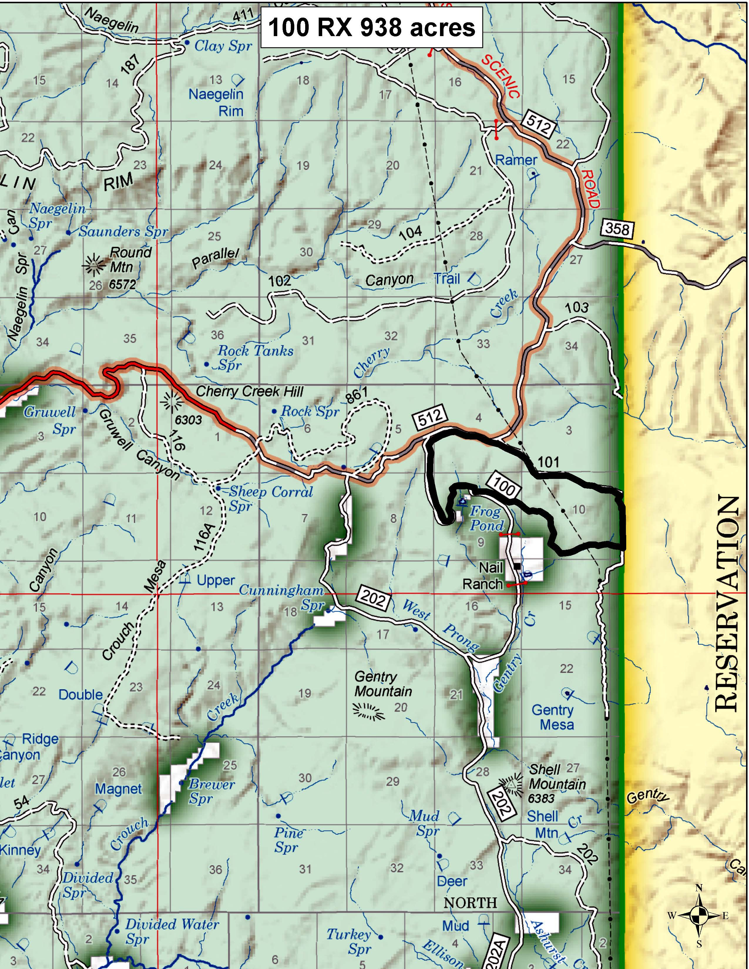
map of prescribed burn Pleasant Valley Ranger District.jpg

map of Pleasant Valley Ranger District prescribed burn
Keywords: 
Prescribed Fire, smoke, smoke impact, Pleasant Valley Ranger District, north of Nail Ranch, Forest Road 512, Tonto National Forest, use extreme caution while driving, Young, Nail Ranch, Frog Pond, Forest Roads 512, 100, 101
Source: 
Arizona Department of Environmental Quality
Apache-Sitgreaves National Forests  Arizona Department of Environmental Quality  Coconino County  Coconino National Forest  Kaibab National Forest  Maricopa County  Mingus Mountain  Navajo County  ozone high pollution advisory  Payson  Prescott National Forest  prescribed burn  Show Low  smoke  Stage 1 fire restrictions  Tonto National Forest  Valentine Fire  wildfire  Yavapai County  Young 

Tweets by AzEIN

Arizona State Seal
  • Contact Us
  • Statewide Web Policies

© 2019 Copyright AZEIN All Rights Reserved

  • Facebook
  • Twitter
  • Youtube
  • RSS