Valentine Fire: Rain Hinders Efforts, Roads Deemed Hazardous for Crews
On Wednesday, firefighting crews were unable to work on the fire line due to the rainfall that occurred on Tuesday night. Instead, key personnel were dispatched to inspect the road conditions to assess their suitability for crew operations. It was concluded that the roads were in such a hazardous state that sending crews along them would pose a risk of ecological damage.
Operations: Crews were kept off the fire line on Wednesday due to the rain fall Tuesday night. Key personnel were out checking road conditions for crews. It was determined that the roads were too much of a hazard and would have caused ecological damage if crews traveled on them. Thursday, Crews will assess road conditions and wetness of fuels to determine if ignitions will be possible in the coming days.
Fire Ecology: Fire behavior ebbs and flows with the weather. Yesterday scattered showers and thunderstorms moved over the Valentine fire. The precipitation and the increase in relative humidity slowed and, in some places, even stopped the fire, but there are some places that will stay mostly dry, even during heavy downpours. Fire burning in heavy pockets of downed trees, deep pockets duff, and underneath or inside of large logs are sheltered and will continue to burn. These areas mostly burn with a ‘smoldering’ fire which burns with no flames, or just very short ones, but sometimes produce a lot of smoke…which is the main way those areas are identified. Fire burning in these areas may continue to burn long after other areas of the fire have gone out.
Weather: The fire area received showers Tuesday night which impacted firing operations. Wednesday showed scattered showers with heavy cloud cover. There is an increased chance for cooler temperatures and higher humidity with chances of isolated thunder showers today.
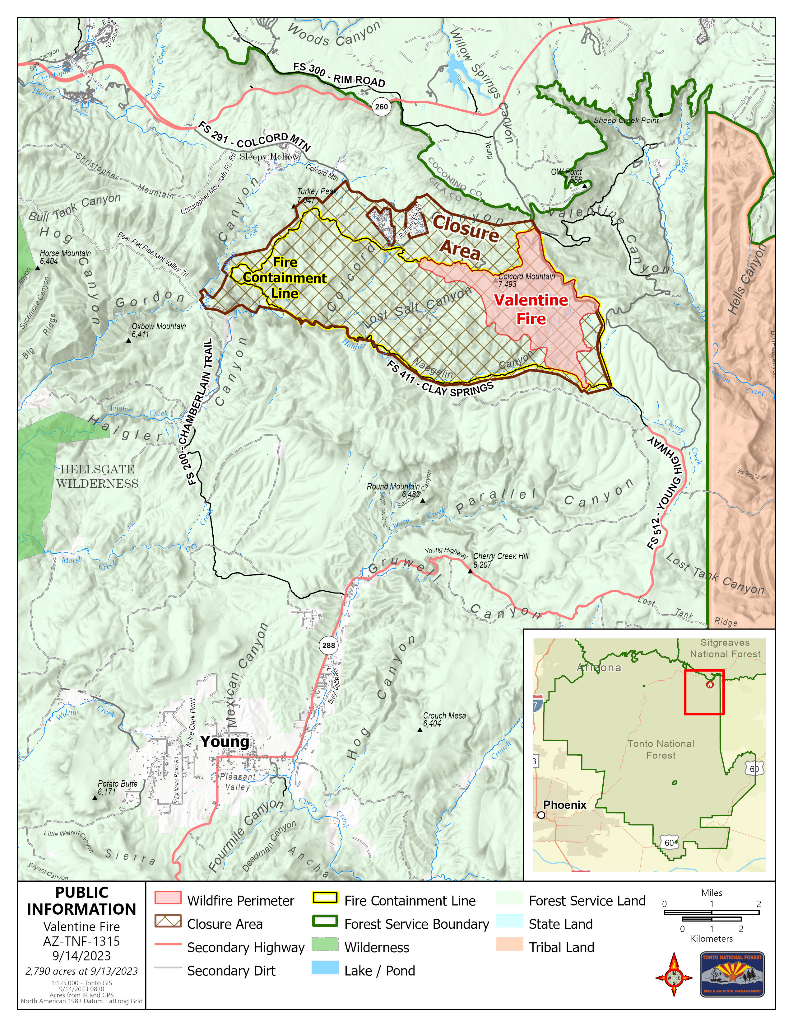
Closures: An emergency closure order for the Valentine Fire will go into effect 6 a.m. Sept. 5, 2023. The public is asked to avoid the fire area. The purpose of the closure order is to protect public health and safety during the Valentine Fire, and to protect assigned firefighting personnel engaging in wildland firefighting operations. Signs and gates will be in place to remind the public not to enter the fire area. Please visit the Alerts and Notices page for more information. https://www.fs.usda.gov/alerts/tonto/alerts-notices.
Safety: The health and safety of firefighters, and the public are always the highest priority. Members of the public are asked to avoid the fire area.
Smoke: Smoke from the Valentine Fire may be visible in the surrounding areas for many days. Smoke will be heavier in the mornings as it settles into the lower elevations and will lift as temperatures increase. Smoke-sensitive individuals and people with respiratory problems or heart disease are encouraged to take precautionary measures An interactive smoke map at https://fire.airnow.gov/ allows you to zoom into your area to see the latest smoke conditions.
Fire details:
- Size: 2,790 acres
- Start Date: August 16, 2023
- Cause: Lightning
- Containment: 49%
- Total personnel: 180
- Location: 11 miles northeast of Young, Arizona and 27 miles east of Payson, Arizona
Information Links and Contacts:
Tonto National Forest https://www.fs.usda.gov/main/tonto/fire
InciWeb https://inciweb.nwcg.gov/incident-information/aztnf-valentine-fire
Fire Email [email protected]
Fire Information Line (928) 421-4579 • Office Hours: 8:00 AM – 8:00 PM


